2.11 Simulations of topographically forced mesocyclones in the Weddell Sea and the Ross Sea region of Antarctica
Günther Heinemann, Meteorologisches Institut Universität Bonn, Auf dem Hügel 20, D-53121 Bonn, Germany; Thomas Klein, Swedish Meteorological and Hydrological Institute, S-60176 Norrköping, Sweden
Mesocyclones (MCs) represent frequent phenomena in the coastal regions of Antarctica. Numerical simulations of topographically forced MCs in the Weddell Sea and the Ross Sea region are presented using a three-dimensional mesoscale weather forecast model. Simulations are performed for an idealized case without synoptic forcing, three realistic cases of smaller MCs with diameters of 200-300 km and two larger systems with diameters of up to 1000 km (subsynoptic cyclones, SSCs). The simulation results show that the topography of the coastal regions can play an important role in mesocyclogenesis. One key factor is the katabatic wind system, which is able to initiate low-level MCs in areas of a suitable topography structure. The second key factor is the support by the synoptic environment, leading to vorticity production by vertical stretching of the synoptically supported katabatic winds. Besides this stretching mechanism, katabatic winds can have a second impact on the generation of MCs by transporting cold air into the coastal areas and thereby enhancing the low-level baroclinicity. A large fraction of short-lived coastal MCs seem to be generated by this mechanism. For larger scale and long-lived MCs, the amplification of a near surface perturbation is found to occur in association with the approach of an upper level potential vorticity anomaly. The initial low-level perturbations, however, seem to be strongly connected to specific topographical features. Since satellite-based climatologies only include MCs associated with cloud formation, a considerable fraction of topographically forced MCs will remain undetected in areas without a mesoscale observational network.
Ross Sea Case
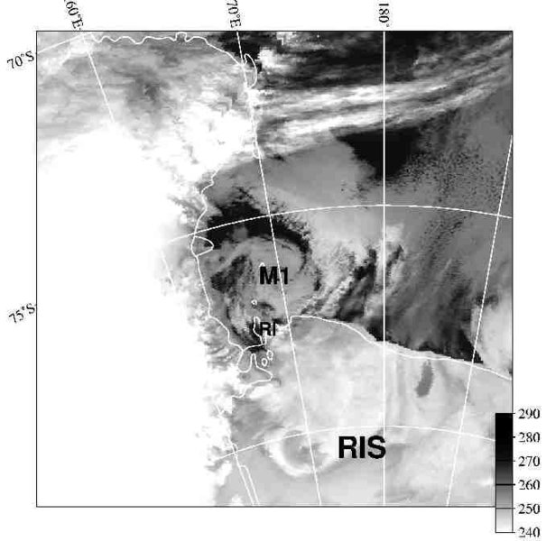
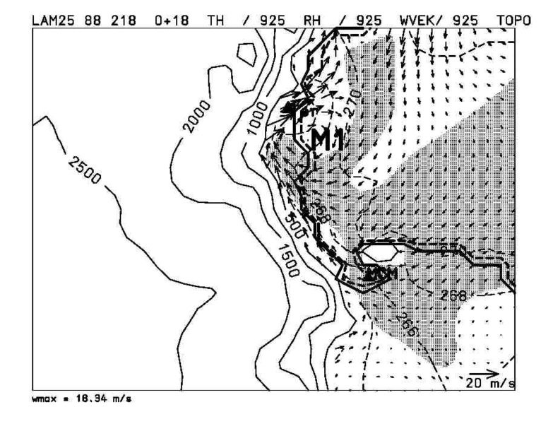
The case of 18 February 1988 is a good example of the interaction of katabatic winds and MCs in the areas of Terra Nova Bay and McMurdo, and have been studied using observations by Bromwich (1991) and Carrasco and Bromwich (1993, 1995) and by Heinemann and Klein (2001) using mesoscale model simulations.
Please click on the images for full resolution or animation.
Weddell Sea case
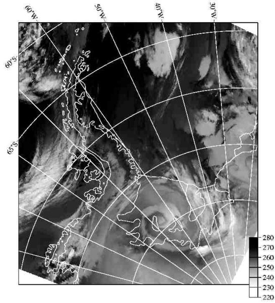
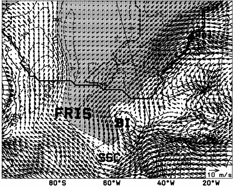
From 11 to 14 February 1990, a MC with a diameter of about 600-1000 km (sub-synoptic cyclone, SSC) was present over the Filchner-Ronne Ice Shelf (FRIS). MC developments detectable in satellite imagery are rare in that part of Antarctica (Heinemann 1990). The MC formed in the morning of 11 February southwest of Berkner Island over the FRIS (Fig.3) and remained quasi-stationary until the evening of 12 February 1990, when it started to move westward. Simulations of Heinemann and Klein (2001) show that upper level support is important for the MC development. The long lifetime and the movement of the MC seem to be a result of the northwards shifting of a 500 Pa cyclonic PV anomaly from about the South Pole towards the center of the FRIS. The vortex develops as a low-level perturbation southwest of Berkner Island, which is forced by the topography structure. Shallow MCs over ice shelves at the bottom of the ice slopes seem to be a common phenomenon, but often they remain undetected in satellite imagery, since they do not show associated cloud patterns.
References:
Bromwich, D. H., 1991: Mesoscale cyclogenesis over the southwestern Ross Sea linked to strong katabatic winds. Mon. Weather Rev. 119, 1736-1752.
Carrasco, J. F., and D. H. Bromwich, 1993: Mesoscale Cyclogenesis Dynamics Over the Southwestern Ross Sea, Antarctica. J. Geophys. Res. 98, 12973-12995.
Carrasco, J. F., and D. H. Bromwich, 1995: A Midtropospheric Subsynoptic-scale Vortex that developed over the Ross Sea and Ross Ice Shelf of Antarctica. Antarctic Sci. 7, 199-210.
Heinemann, G., 1990: Meso-scale vortices in the Weddell Sea region. Mon. Wea. Rev. 118, 779-793.
Heinemann, G., Klein, T., 2001: Simulations of topographically forced mesocyclones in the Weddell Sea and the Ross Sea region of Antarctica. In review by Mon. Wea. Rev.
Please click on the images for full resolution or animation.