2. Reports of current polar low research
2.8 A similar initialization technique using derived doppler radar data for numerical simulations of mature tropical cyclones and polar lows
O. Nuissier and F. Roux, Laboratoire d’Aérologie, UMR 5560 CNRS – Université Paul Sabatier, Toulouse, France
INTRODUCTION
Polar lows are deep but less intense oceanic depressions than tropical cyclones, which form when cold air outbreaks coming from ice-covered regions occur over relatively warmer open waters. At a first glance, they seem to be different as they evolve in different meteorological environments. Some of polar lows can however generate strong winds up to more 30 m.s-1 and heavy snowfalls at their mature stage. Furthermore, some satellite observations suggest that polar lows and tropical cyclones have common characteristics at their mature stage: symmetric cloud signatures, a warm core structure, deep convection surrounding a clear "eye",… (Shapiro et al. 1987). The Air-Sea mechanism interaction or WISHE (Wind Induced Surface Heat Exchange) discussed by Emanuel et al. (1994), appears to be the most important process in the mature stage of both phenomena. In this study and through this similarity, we attend to show that it is possible to simulate close realistic characteristics of polar lows through the introduction of information, in the first step of the simulation, derived from Doppler radar data and available for tropical cyclones.
EXPERIMENT DESIGN
Model description
A three-dimensional version of the French Méso-NH nonhydrostatic mesoscale numerical model is used for the present study. The Méso-NH Atmospheric Simulation System is a joint effort of Centre National de Recherches Météorologiques (Météo-France) and Laboratoire d’Aérologie (CNRS) (Lafore et al., 1998). The basic atmosphere variables are temperature, pressure, density of the dry fraction of the air and total density of moist air. The prognostic variables of the model are the three Cartesian components of velocity, the dry potential temperature and the different water mixing ratios. The turbulent fluxes, more particularly sensible heat and water vapour fluxes, are calculated by aerodynamic formulae with wind-dependent exchange coefficients.
Vortex and environmental conditions specification
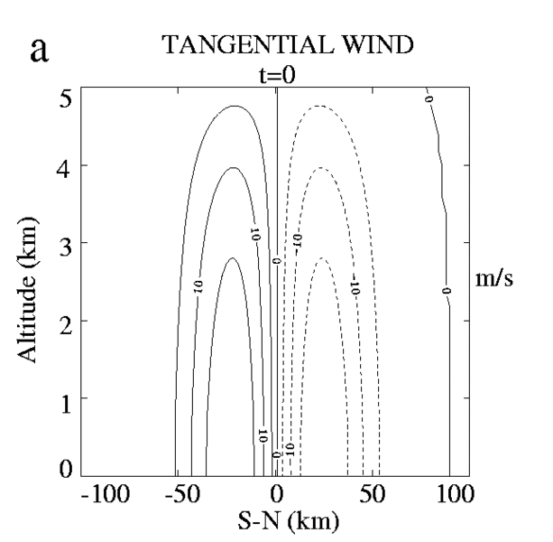
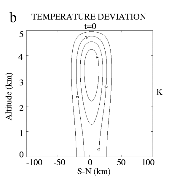
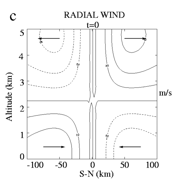
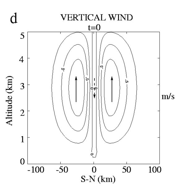
Méso-NH has been initialized with a symmetric analytical warm core vortex inspired from the Extended Velocity Track Display (EVTD) analysis of airborne Doppler radar observation of Hurricane Claudette on 7 September 1991 (Roux and Viltard, 1995; Viltard and Roux, 1998). Here we present only the vortex specified for the polar low, which has a tangential circulation with a maximum wind of 20 m.s-1 at 25 km from the center (Fig. 1a), in gradient wind balance with a temperature deviation reaching 5 K at 3.3 km altitude (Fig. 1b). The secondary circulation exhibits inflow in the lower part of troposphere, a main updraft at the radius of maximum wind (RMW), an outflow above, and weaker downward motion at the center (Fig 1c,d).
In order to simplify the study, homogenous environmental conditions with a limited extension are used for the experiments. Although the background fields are not really realistic, such a procedure is sufficient to test the ability of the numerical model to i) react satisfyingly to the initial forcing and ii) simulate hurricane and polar low structures. The vortex is embedded in an environment where the Convective Available Potential Energy (CAPE) is weak and no large-scale wind is prescribed. The sea surface temperature (SST) was kept at 5°C and different sensitivity tests have been performed concerning air temperature in order to study the intensification of initial cyclonic circulation through surface fluxes. Two thermodynamic profiles have been used (not shown): a relatively "warm" environmental one with an air-sea difference temperature of 5°C, and a "cold" one with a difference of 25°C. These configurations will be referred to as polar low 1 (P.L.1), and 3 (P.L.3) As it is a feasibility study, the horizontal domain used for this study (300 km * 300 km) with a horizontal grid spacing of 2 km was taken deliberately small. With this domain size, we do not attempt to reproduce the whole system, but only the inner-core region of polar low.
SOME IMPORTANT RESULTS
After being initialized with the fields described above, the model has been integrated during a period of 10 hours. However, we present only results for the polar low and from the first five hours where the most of the kinematic, thermodynamic and microphysical perturbations occurred.
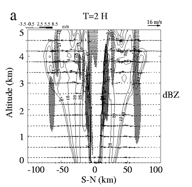
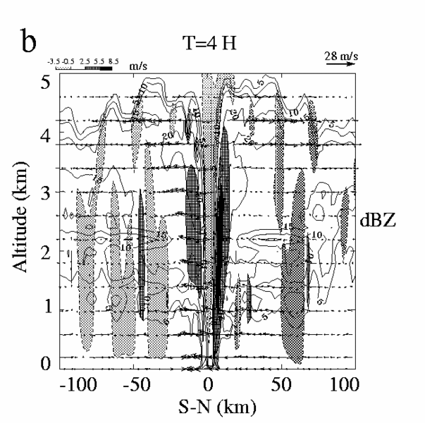
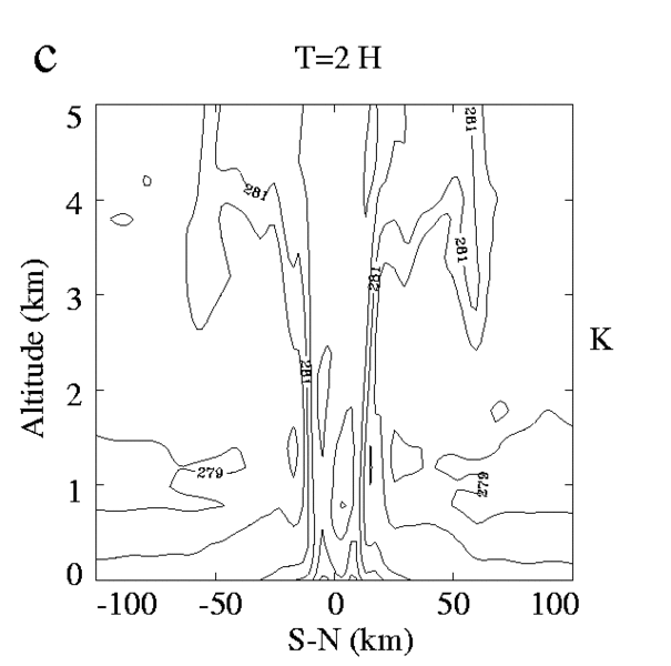
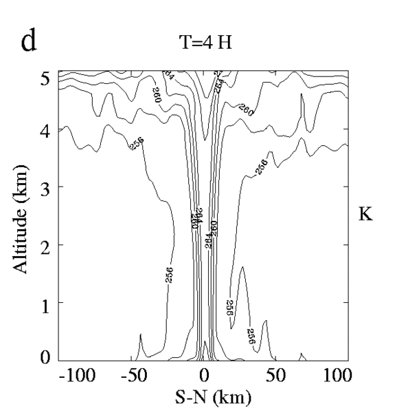
In agreement with previous observations, the model reproduces a cloud-and precipitation-free eye at the center of the disturbances and the regions of maximum wind are well related to intense vertical motions and precipitations, fed by a strong inward increase of qE in the lower-levels resulting from intense heating and moistening by the surface fluxes (Fig. 3c,d).
Comparison of vertical microphysical structures of both polar lows (Fig. 2a,b) shows that P.L.1 is a "wet polar storm" with intense snowfall reaching the surface until 4 h of simulated time, whereas P.L.3 is a "dry polar low" with less precipitations. The radial and vertical circulations (Figs. 2a,b) show structures qualitatively close to those obtained for the case of a tropical cyclone, with low-level inflow (up to 15 m.s-1), strong updraft near the center of the storm (up to +7 m.s-1), and an impressive upper-level outflow forming a large ice-anvil. This last feature is quite obvious for the P.L.3 case. An other interesting characteristic appears in the polar lows’ eyes with ice-particles generated by deep convection which are detrained from the eyewall and produce enhancement of subsidence by sublimative cooling in the drier environment of the eye.
PERSPECTIVES
Although the Méso-NH model was able to reproduce realistic structures of mature idealized polar lows, the major impact of the initialisation technique lasted during a 5-h period nearly, probably due to the use of quite idealized environmental conditions. The major effect is that, due to the lack of coupling with larger scale phenomena, the simulated cyclonic circulations can rapidly reach their maximum potential intensity. Indeed, a series of others experiments for Hurricane Bret (1999) with "actual" Doppler radar embedded in a large-scale analysis showed more appreciable simulated intensification rates and life time. It will be interesting to apply this "improved" technique to a real polar low case over the Norwegian Sea on 15 October 1993: the "Swan".
References
Emanuel, K. A., J. D. Neelin, and C. S. Bretherton, 1994: On large-scale circulations is convecting atmospheres. Quart. J. Roy. Meteor. Soc., 120, 1111-1144.
Lafore, J. P., J. Stein, N. Ascencio, P. Bougeault, V. D. Ducrocq, J. Duron, C. Fisher, P. Hereil, P. Mascart, J.-P. Pinty, J.-L. Redelsperger, E. Richard, and J. Vila-Guerau de Arellano, 1998: The Méso-NH Atmospheric Simulation System. Part I: Adiabatic formulation and control simulations. Ann. Geophys., 16, 90-109.
Roux, F., and N. Viltard, 1995: Structure and evolution of Hurricane Claudette on 7 September 1991 from airborne Doppler radar observations. Part I: Kinematics. Mon. Wea. Rev., 123, 2611-2639.
Shapiro, M., L. S. Fedor, and T. Hampel, 1987: Research aircraft measurements of a polar low over the Norwegian Sea. Tellus, 39A, 272-306.
Viltard, N., and F. Roux, 1998: Structure and evolution of Hurricane Claudette on 7 September 1991 from airborne Doppler observations. Part II: Thermodynamics. Mon. Wea. Rev., 126, 281-302.
Please click on the images for full resolution or animation.