
Ladamer
Land Degradation Assessment in Mediterranean Europe
Consortium
| Remote Sensing Department (FEUT), Faculty of Geography/Geosciences, Universität Trier, Germany |  |
| Soil and Waste Unit (SWU), Institute for Environment and Sustainability, Directorate General Joint Research Centre, Ispra, Italy (EC-JRC-SWU) |  |
| Estacion Experimental de Zonas Aridas, Consejo Superior de Investigaciones Cientificas (EEZA-CSIC), Almeria, Spain |  |
| Research Institute for Knowledge Systems (RIKS), Maastricht, The Netherlands |  |
| Departamento de Geografia e Planeamento Regional, Faculdade de Ciências Sociais e Humanas da Universidade Nova de Lisboa, Lisbon, Portugal (DGPR-FCSH-UNL) |  |
Project Summary
Problems to be solved
In the five EU countries of the Mediterranean Basin natural resources are intensively utilised. While most of the land uses have undergone long evolutions and traditionally were sustainable, changing socio-economical and political frameworks have partly led to deviations from the former equilibrium. In Mediterranean ecosystems, the combination of socio-economic boundary conditions and the specific physical determinants often lead to the degradation of natural resources. These degradation processes may manifest in an accelerated erosion of soil, which is a limited resource of high importance to human welfare in many respects, or vegetation degradation that is directly inter-connected with soil properties and vice versa.
The LADAMER project shall contribute to the protection of the natural environment by providing products relevant for planners and political agents. This is in accordance with the European Treaty requiring that "environmental protection must be integrated into the definition and implementation of the other Community policies". It also contributes strongly to the mitigation and prevention of land degradation, which is considered a major threat to Mediterranean ecosystems. Hence, sustainable land management contributes to the National Action Plans that have been established as a consequence of the UN Convention to Combating Desertification. Important to mention is recent COM on soil as well as planned legislation on soil monitoring.
Scientific objectives and approach
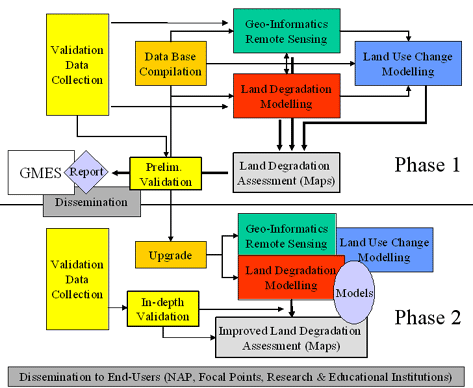
The project encompasses two separate phases. The first phase will start with the procurement and processing of considerable volumes of geoscientific, socio-economic and remotely sensed data covering the Mediterranean basin. One accompanying element will be the identification of shortcomings and obstacles in accessing and compiling the datasets. The establishment of this unified data base will provide the basis for spatio-temporal analyses and the production of a regional land degradation map for the Mediterranean member states of the European Union. Together with the processed geo-data layers and spatialised socio-economic variables, this information will flow into a concept model to produce a land degradation assessment. Phase II will be devoted to a more in-depth validation, the integration of additional or improved data layers, and the evaluation of advanced methodological options to upgrade the quality and information content of models and products.
Expected impacts
The required base data for the LADAMER project largely exist but are scattered across various European and international institutions. They need to be assembled in a consistent and well-documented data base. A second result will be a regional assessment of the land degradation status in Mediterranean Europe, based on an existing theoretical framework. In this context, remotely sensed vegetation density is compared to a model-determined reference density. Moreover, regional change maps of vegetation density and land-use classes over time will be derived from remote sensing data analysis and coupled with the before mentioned results to evaluate their performance for early warning and monitoring purposes. The last objective is to couple the existing data, information, knowledge and models into an integrated assessment model, capable to combine different process domains with respect to early warning and environmental surveillance. Finally, the derived products will be validated.
The combined output of LADAMER will present a comprehensive as well as spatially explicit image of land degradation effects and associated processes for the relevant European Mediterranean countries. It will hence serve as a kind of integrating project between former research approaches and ongoing monitoring and assessment efforts. Besides providing dedicated information products, LADAMER will build a basis for further GMES developments by identifying missing elements in the necessary range of data, in particular with respect to the establishment of a European monitoring capacity of land and soil resources.
Methods
Project Structure
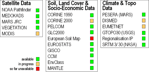
Used Databases
See Methods for more information.
Downloads
GMES report 2003 - LADAMER 10 pages synthesis.pdf, 370 kB
GMES report 2003 - LADAMER Full details report.pdf, 3254 kB
GMES-Paper Nordwijk.pdf, 670 kB
Contact
LADAMER - Land Degradation Assessment in Mediterranean Europe is co-ordinated by Prof. Dr. Joachim Hill, head of the Remote Sensing Department of the University of Trier, Germany.
Responsible for the development of this web site are Marion Stellmes, scientific staff at the department and in charge of the LADAMER project work, and Henning Buddenbaum, auxiliary staff at the Remote Sensing Department.
Universität Trier
FB VI Geography/Geosciences
Remote Sensing Department
Behringstrasse 15
D-54286 Trier Germany
Tel.: +49-651-2014591 (secretary)
Fax: +49-651-2013815
Web: www.Feut.de
For further information, please direct your inquiry to