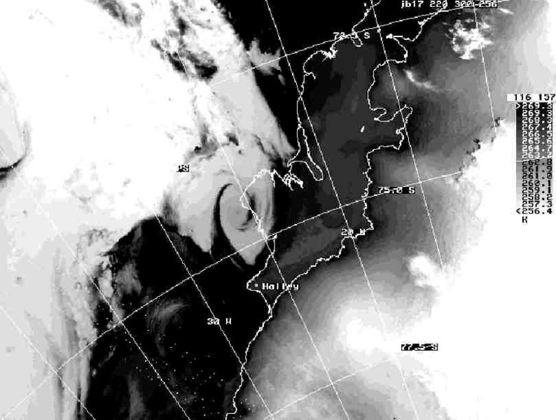
Coastal MC in the Weddell Sea 19 January 1990
In the coastal area of the eastern Weddell Sea, a frequency maximum for summertime MC developments was observed in the climatological study of Heinemann (1990) which was based on NOAA- and METEOR-APT (Automatic Picture Transmission) images (resolution about 4 km and 2 km respectively) for January and February of the summer periods 1983-1988. This study was extended to include the summer periods 1989-1990 by Heinemann (1996). In total, 286 vortices were observed in 346 days during the summer periods 1989-1990. With the exception of February 1985, the short-lived vortices with a lifetime less than 12 h represent the largest class for all years and were found account for 72 % of the smaller-scale types (100-400 km).
The MC on 19 January 1990 represents a typical example of summertime coastal MCs. It developed close to Halley Station (75.60S/26.78W), and had scales of about 200-300 km and their lifetime was about 12 h. Cloud top temperatures from satellite data indicated a shallow vertical extent being confined to the lowest 2 km. For this case the German research vessel Polarstern operated close to the MC and wind observations at Halley and Polarstern indicated a cyclonic circulation with a wind speed of up to about 10 m/s. During the afternoon and evening of 19 January, Polarstern lay at a distance of only 100-150 km from the vortex centre. This MC was investigated using aircraft measurements during the AMES experiment. A detailed description of this case is given in Heinemann (1996).
References:
Heinemann, G., 1990: Meso-scale vortices in the Weddell Sea region. Mon. Wea. Rev. 118, 779-793
Heinemann, G., 1996: Three-dimensional structures of summertime Antarctic meso-scale cyclones: Part I: Observational studies with aircraft, satellite and conventional data. Global Atmosphere-Ocean System 4, 149-180.
Engels, R., Heinemann, G., 1996: Three-dimensional structures of summertime Antarctic meso-scale cyclones: Part II: Numerical simulations with a limited area model. Global Atmosphere-Ocean System 4, 181-208.
Please click on the images for full resolution or animation.
Copyright by Günther Heinemann.